Understanding the great migration through Mara Serengeti Migration Map
The Great Migration stands as one of nature’s most awe-inspiring phenomena, a continuous movement of over 1.5 million wildebeest, accompanied by hundreds of thousands of zebras, gazelles, and other herbivores, traversing the vast plains of East Africa. You should see this, its just fantastic site. At Twinkle Star Tours and Safaris, we provide an in-depth look at this extraordinary journey through our comprehensive Mara Serengeti migration map.
Stretching from the Ngorongoro Conservation Area and southern Serengeti plains in Tanzania to the northern reaches of the Masai Mara in Kenya, this incredible wildlife spectacle covers an ecosystem that encompasses multiple national parks, conservation areas, and game reserves. The interconnected nature of these protected lands is what allows this ancient migration pattern to continue, creating what many consider the greatest wildlife show on Earth.
Following the Great Migration Map
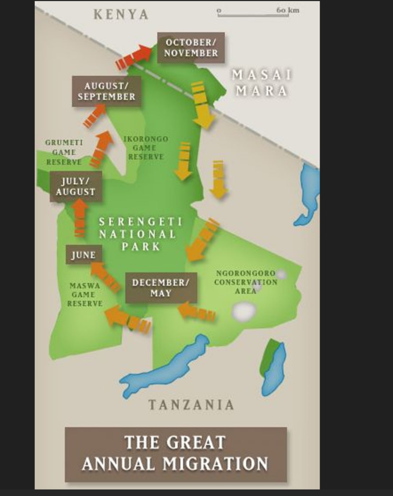
The great migration map reveals a clockwise, cyclical pattern that spans approximately 1,800 miles through Tanzania’s Serengeti National Park and Kenya’s Masai Mara National Reserve. This perpetual movement is driven by one crucial element: the search for fresh grazing lands and water. As displayed on our Serengeti migration map, the herds follow the rain patterns across the ecosystem, constantly seeking greener pastures.
The migration route takes advantage of natural corridors between protected areas, crossing three major rivers—the Mara, Grumeti, and Mbalageti—each presenting formidable obstacles for the traveling herds. Our detailed Mara Serengeti map shows the precise paths these animals take throughout the year, which we’ll explore month by month.
December to May: Southern Serengeti and Ngorongoro
The great migration map shows that from December through May, the massive herds concentrate in the southern plains of the Serengeti National Park and Ngorongoro Conservation Area. This period coincides with the calving season, typically occurring between January and March, when approximately 400,000 wildebeest calves are born within a remarkable three-week window. The nutritious short-grass plains provide ideal conditions for the newborns and their mothers.
During this phase of the migration, the herds spread across.
- The southern Serengeti plains near Lake Ndutu
- Ngorongoro Conservation area which is outside the famous crater
- Parts of Maswa Game Reserve to the west
The abundance of predators, lions, cheetahs, leopards, and hyenas, makes this stage of the migration particularly dramatic, as vulnerable calves become targets for hungry predators. Visitors accessing this region often use the Naabi Hill Gate, as shown on our Masai Mara and Serengeti map, with accommodation options near Lake Ndutu offering prime viewing opportunities.
June: Western Corridor and Grumeti River
As the dry season approaches, our Mara Serengeti map illustrates how the herds begin their northward journey in June. The wildebeest columns stretch for miles as they move through the Western Corridor of the Serengeti, heading toward the Grumeti Game Reserve. As clearly shown on our detailed map, this stage features one of the first major obstacles: crossing the crocodile-infested Grumeti River near the Kirawira Plains.
Access to this region is primarily through the Grumeti Gate, with several nearby airstrips (marked on our Serengeti migration map) serving the Western Corridor. Accommodations in this area provide front-row seats to the dramatic river crossings that offer some of the most heart-stopping moments of the entire migration cycle.
July to August: Northern Serengeti and Masai Mara Arrival
By July and August, the migration reaches the northern Serengeti and begins crossing into Kenya’s Masai Mara National Reserve. According to our detailed Masai Mara National Park map, the herds must overcome the treacherous Mara River—arguably the most famous and perilous crossing of the entire journey. The banks of the Mara River are lined with massive Nile crocodiles that have patiently waited for this annual feast.
The Masai Mara best time to go is undoubtedly during this period if your primary goal is to witness the dramatic river crossings. Visitors can access the northern Serengeti via the Fort Ikoma Gate or Klein’s Gate, both marked on our map, with convenient airstrips nearby. Once in Kenya, the Kogartende area along the Mara River offers exceptional viewing opportunities as the herds gather before making their crossing attempts. The herds typically remain in the Masai Mara until October, spreading across the lush plains as they graze on the abundant grasses nourished by earlier rains.
August to September: Heart of the Masai Mara
August and September find the wildebeest herds fully established in the Masai Mara. Our Mara Serengeti map shows how they disperse across the northern plains, often splitting into smaller groups that spread throughout the reserve. Visitors can access prime viewing areas in the Masai Mara through established entry points, with the Oloololo Gate on the western side and several airstrips (clearly marked on our map) serving the reserve.
This period represents the peak wildlife viewing season in the Masai Mara, with predator action intensifying as lions, cheetahs, and leopards capitalize on the abundant prey. The presence of big cats, as illustrated on our Mara Serengeti map with animal icons, is particularly notable in the central plains of the Masai Mara, where the large herds attract numerous predators.
Visitors during this time are treated to the quintessential East African safari experience, golden plains dotted with thousands of animals as far as the eye can see. The acacia-dotted landscape creates the iconic African savannah vistas that have made this region famous worldwide.
October to November: Returning South
By October and November, the short rains begin in the Serengeti, prompting the herds to begin their southward journey. The great migration map illustrates how the animals travel along the eastern edge of the Serengeti past Seronera and the Central Plains, heading back toward the southern plains to complete the cycle.
This less-visited phase of the migration offers unique opportunities to witness the massive columns of animals on the move without the crowds that characterize the more famous river crossing periods. The central Serengeti region, accessible via the Seronera Airstrip (marked on our map), becomes an important transitional zone during this period.
Reading the Mara Serengeti Map
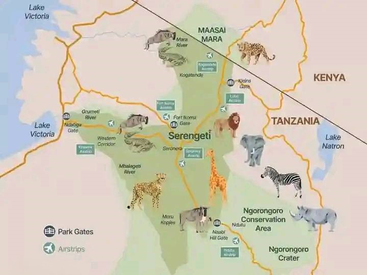
Understanding the great migration map helps travelers identify the key regions that play crucial roles in this wildlife spectacle. Our detailed maps show the geographic features, access points, and wildlife distributions across this vast ecosystem.
Masai Mara National Reserve Kenya
The northernmost point of the migration, Kenya’s Masai Mara covers approximately 1,510 square kilometers of primarily open grassland. The reserve is characterized by:
- The Mara River, featuring multiple crossing points visible on our map
- Rolling hills and plains offering exceptional visibility
- Scattered acacia trees providing shade for predators
- Key landmarks like Kogatende along the river
- Various entry gates and airstrips providing access from different directions
The Masai Mara National Park map reveals that the reserve is actually an extension of the greater Serengeti ecosystem, with only the political boundary (marked as a thin line on our map) separating it from Tanzania’s Serengeti National Park to the south. This continuity allows for the free movement of wildlife across national borders.
Serengeti National Park Tanzania
Tanzania’s Serengeti National Park forms the core of the migration ecosystem, covering a vast 14,750 square kilometers. As illustrated in our Serengeti migration map, the park can be divided into several distinct regions:
- Northern Serengeti: Bordering the Masai Mara and featuring the Mara River, accessible via Klein’s Gate and Fort Ikoma Gate
- Western Corridor: A narrow stretch extending toward Lake Victoria, containing the Grumeti River and accessed via the Grumeti Gate
- Central Serengeti (Seronera): The heart of the park, known for resident wildlife, abundant predators (marked with animal icons on our map), and served by the Seronera Airstrip
- Southern Plains: The vast grasslands near Lake Ndutu where calving occurs, accessed via Naabi Hill Gate
Each region plays a vital role in the annual migration cycle, providing specific resources needed by the herds at different times of the year. The network of airstrips shown on our Masai Mara and Serengeti map allows visitors to efficiently access different regions according to the migration’s current location.
Surrounding Conservation Areas and Geographic Features
The complete Mara Serengeti map includes several additional protected areas and important geographic features that form part of the greater ecosystem:
- Ngorongoro Conservation Area: Adjacent to the southern Serengeti, featuring the famous Ngorongoro Crater (clearly marked on our second map)
- Maswa Game Reserve: Bordering the southwestern Serengeti
- Grumeti Game Reserve: Along the western corridor, with the Grumeti River flowing through it
- Ikorongo Game Reserve: North of Grumeti, an important transitional zone for migrating herds
- Lake Victoria: The massive freshwater lake visible on the western edge of our map
- Lake Natron: The alkaline lake to the east of the ecosystem
These protected areas and natural features ensure the preservation of the entire ecosystem necessary for the migration’s continuation. As our detailed map shows, the network of roads (marked in yellow) connects these various regions, allowing for comprehensive exploration of the greater Mara-Serengeti ecosystem.
Timing Your Safari while Using the Great Migration Map as a Guide
One of the most common questions we receive at Twinkle Star Tours and Safaris is: “When is the Masai Mara best time to go to witness the migration?” The answer depends entirely on which aspect of the migration you most want to experience.
Our detailed Mara Serengeti migration map, with its clear monthly indicators and directional arrows, serves as an invaluable planning tool, helping visitors align their safari dates with the migration’s location:
- December to May: Southern Serengeti and Ngorongoro Conservation Area for calving season (approximately 400,000 calves born within three weeks)
- June: Western Corridor for the Grumeti River crossings near Kirawira Plains
- July to August: Northern Serengeti for the initial Mara River crossings near Kogatende
- August to September: Masai Mara for peak wildlife density and continued river crossings
- October to November: Central and eastern Serengeti for the return journey south
- Year-round: Central Serengeti (Seronera) offers excellent resident wildlife viewing regardless of migration timing
It’s important to note that while the great migration map provides a reliable general pattern as shown by the directional arrows and monthly labels, the exact timing can vary by a few weeks each year depending on rainfall patterns. The animals follow the rain, so unusual weather can alter their movements somewhat.
Accessing the Migration Through Main Gates and Airstrips
Our detailed map shows the key access points throughout the ecosystem:
Park Gates:
- Naabi Hill Gate: Main southern entrance to the Serengeti
- Grumeti Gate: Western access point
- Fort Ikoma Gate: Northwestern entrance
- Klein’s Gate: Northeastern access point
- Various Masai Mara gates: For the Kenyan portion of the ecosystem
Airstrips:
As marked on our Masai Mara and Serengeti map with airplane icons, numerous airstrips serve different regions:
- Seronera Airstrip: Central Serengeti
- Kogatende Airstrip: Northern Serengeti
- Grumeti Airstrip: Western Corridor
- Ndutu Airstrip: Southern Serengeti
- Multiple Masai Mara airstrips: Throughout the reserve
These transportation options allow visitors to efficiently target specific migration events without spending excessive time on road transfers.
What the Mara Serengeti Map Doesn’t Show
While our detailed Mara Serengeti map illustrates the geographic scope and timing of the migration, there are aspects of this natural phenomenon that can only be fully appreciated in person:
The Scale
No map can truly capture the sheer magnitude of the migration. When standing on the plains of the Masai Mara or Serengeti, witnessing tens of thousands of animals stretching to the horizon, the scale becomes almost overwhelming. The thundering sound of hooves, the calls of the animals, and the clouds of dust create a sensory experience that transcends any two-dimensional representation.
The Drama
The great migration map shows routes and timing but cannot convey the intense drama that unfolds daily. Predator-prey interactions, the urgency of river crossings, and the social dynamics within the herds create constant moments of tension, excitement, and wonder.
The Supporting Cast or Rather other Animals
While wildebeest are the stars of the migration, our Masai Mara National Park map and Serengeti migration map represent ecosystems teeming with other wildlife. As illustrated by the animal icons on our second map, the region hosts an incredible diversity of species:
- Lions: Particularly concentrated in the central Serengeti and Masai Mara
- Leopards: Often found in areas with scattered trees and rocky outcrops
- Cheetahs: Hunting on the open plains throughout the ecosystem
- Elephants: Common in the northern Serengeti and parts of the Mara
- Rhinoceros: Primarily in the Ngorongoro Crater, as indicated on our map
- Giraffes: Widely distributed throughout the savannah regions
- Zebras: Migrating alongside the wildebeest in substantial numbers
- Buffalo: Found in herds across both the Serengeti and Masai Mara
These resident and migratory animals add layers of richness to the migration experience, creating one of the most biodiverse wildlife spectacles on the planet.
The Landscape Diversity
While our map shows the general topography, it cannot fully convey the beautiful variations in landscape throughout the ecosystem:
- The kopjes (rocky outcrops) of the central Serengeti
- The meandering rivers lined with riverine forests
- The sweeping vistas from elevated viewpoints
- The changing vegetation patterns from grassy plains to acacia woodlands
- The dramatic skies and lighting conditions that photographers cherish
Planning Your Great Migration Safari with Twinkle Star Tours and Safaris
Using our comprehensive Mara Serengeti map as a guide, we help travelers design the perfect migration safari which can be through masai mara safari packages, Serengeti safari packages or combined Masai mara Serengeti itinerary safari. Here are key considerations for planning your journey:
Location Selection Based on Timing
By consulting our detailed masai mara Serengeti great migration map, with its clear monthly markers and directional arrows, we can recommend the optimal locations based on your travel dates:
- If traveling in July-October, focus on the Masai Mara and northern Serengeti (Kogatende area)
- For December-May, concentrate on the southern Serengeti plains and Ngorongoro Conservation Area
- June visitors should target the Western Corridor and Grumeti River area
- October-November travelers might explore the central Serengeti as herds move through Seronera
Strategic Access Points
Our Mara Serengeti map clearly shows the key access points that serve different regions throughout the year:
- Southern Circuit: Enter through Naabi Hill Gate to access the calving grounds in December-May
- Western Access: Use Grumeti Gate for June river crossings
- Northern Circuit: Fort Ikoma Gate and Klein’s Gate provide access to the July-August migration
- Masai Mara Entry: Multiple gates serve the Kenyan sector during August-October
Accommodations Along the Route
The Mara Serengeti migration map helps identify strategic accommodation locations:
- Mobile tented camps that follow the migration’s path through the ecosystem
- Permanent lodges in key wildlife corridors near the airstrips marked on our map
- Riverside lodges near major crossing points on the Mara and Grumeti Rivers
- Exclusive accommodations in less crowded sectors of the parks and reserves
Transportation Between Regions
For travelers hoping to witness multiple phases of the migration, our Masai Mara and Serengeti migration maps guide logistical planning:
- Flight connections between airstrips clearly marked on our map
- Border crossing procedures between Kenya and Tanzania
- Road transfer options along the yellow routes shown on our map
- Charter flight possibilities for accessing remote areas
Wildlife Viewing Strategy
The animal icons on our map help identify areas known for specific wildlife concentrations:
- Big cat concentrations in the central Serengeti and Masai Mara
- Elephant herds in the northern regions
- Rhino viewing in the Ngorongoro Crater
- Riverine species along the Mara, Grumeti, and Mbalageti Rivers
Conclusion
The Mara Serengeti migration map represents one of nature’s most spectacular cyclical journeys—a constant movement driven by ancient instincts and environmental cues. At Twinkle Star Tours and Safaris, we invite you to witness this extraordinary natural phenomenon, using our expert knowledge of the migration patterns to position you at the right place, at the right time.
The great migration stands as a powerful reminder of nature’s resilience and the importance of preserving large, connected ecosystems. Whether you’re drawn to the dramatic river crossings at Kogatende, the breathtaking spectacle of the calving season near Ndutu, or simply the overwhelming presence of life on the savannah around Seronera, the Great Migration offers wildlife experiences that remain forever etched in memory.
Our detailed Mara Serengeti map serves as both a practical planning tool and a testament to one of the planet’s most remarkable natural cycles. By understanding the geographic features, seasonal movements, and access points illustrated on these maps, you can experience the ultimate East African safari adventure.
Contact Twinkle Star Tours and Safaris today to plan your journey following the ancient paths revealed on our comprehensive Mara Serengeti migration map.