Here is a complete Masai Mara National Reserve map which you can also refer to Google Maps for a specific thing in the map. Whether you’re planning your first maasai mara safari adventure or returning to this magnificent landscape, understanding the geography of the Masai Mara will enhance your experience tremendously.
Understanding the Masai Mara National Reserve Map
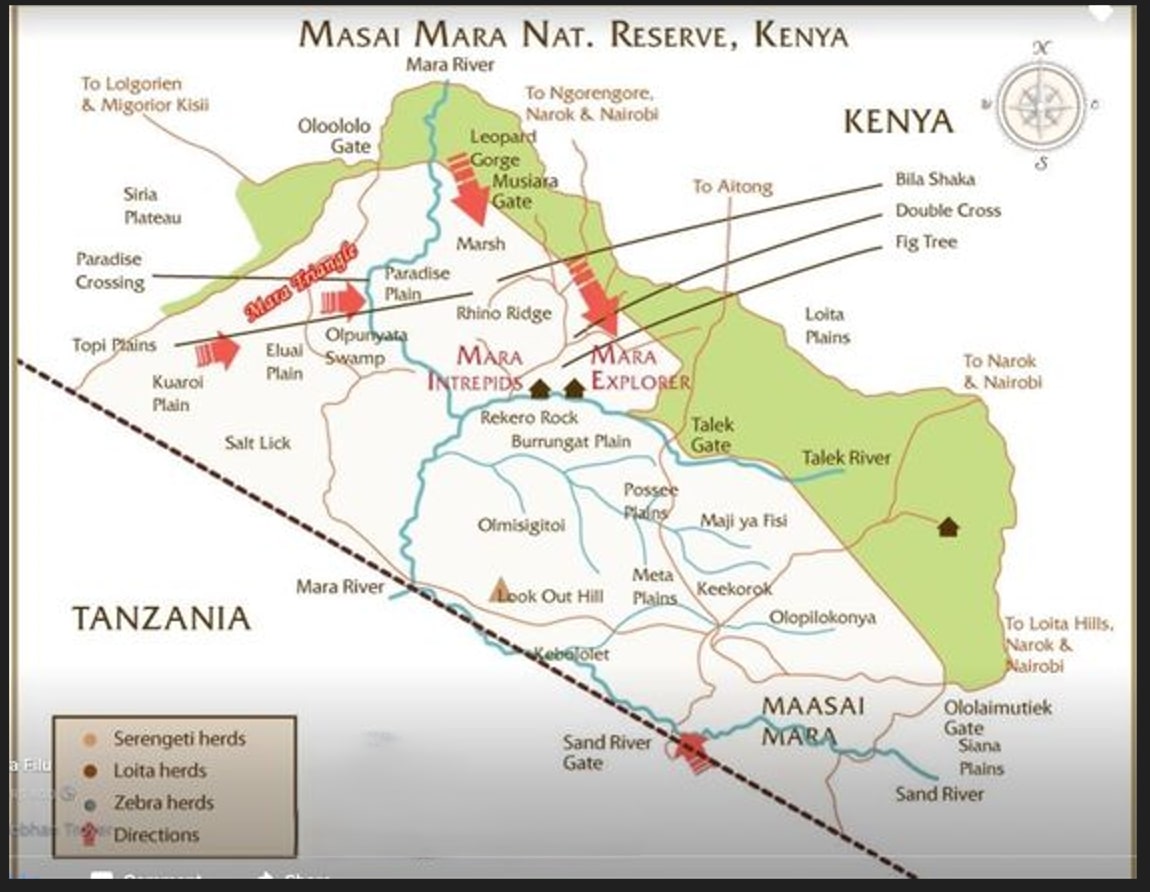
The Masai Mara National Reserve covers approximately 1,510 square kilometers of breathtaking savannah in southwestern Kenya. As one of Africa’s most celebrated wildlife conservation areas, the reserve forms the northern continuation of Tanzania’s Serengeti National Park and is an essential component of the greater Serengeti ecosystem. The reserve is bordered by Tanzania to the south, with the border clearly marked on the map. This is where the 8th wonder of the world The Great Wildebeest migration phenomena takes place.
The Masai Mara Kenya map reveals a diverse landscape characterized by:
- Numerous plains including Paradise Plain, Rhino Ridge, Topi Plains, Kuaroi Plain, Eluai Plain
- The Mara River winding through the reserve with crossing points for wildlife
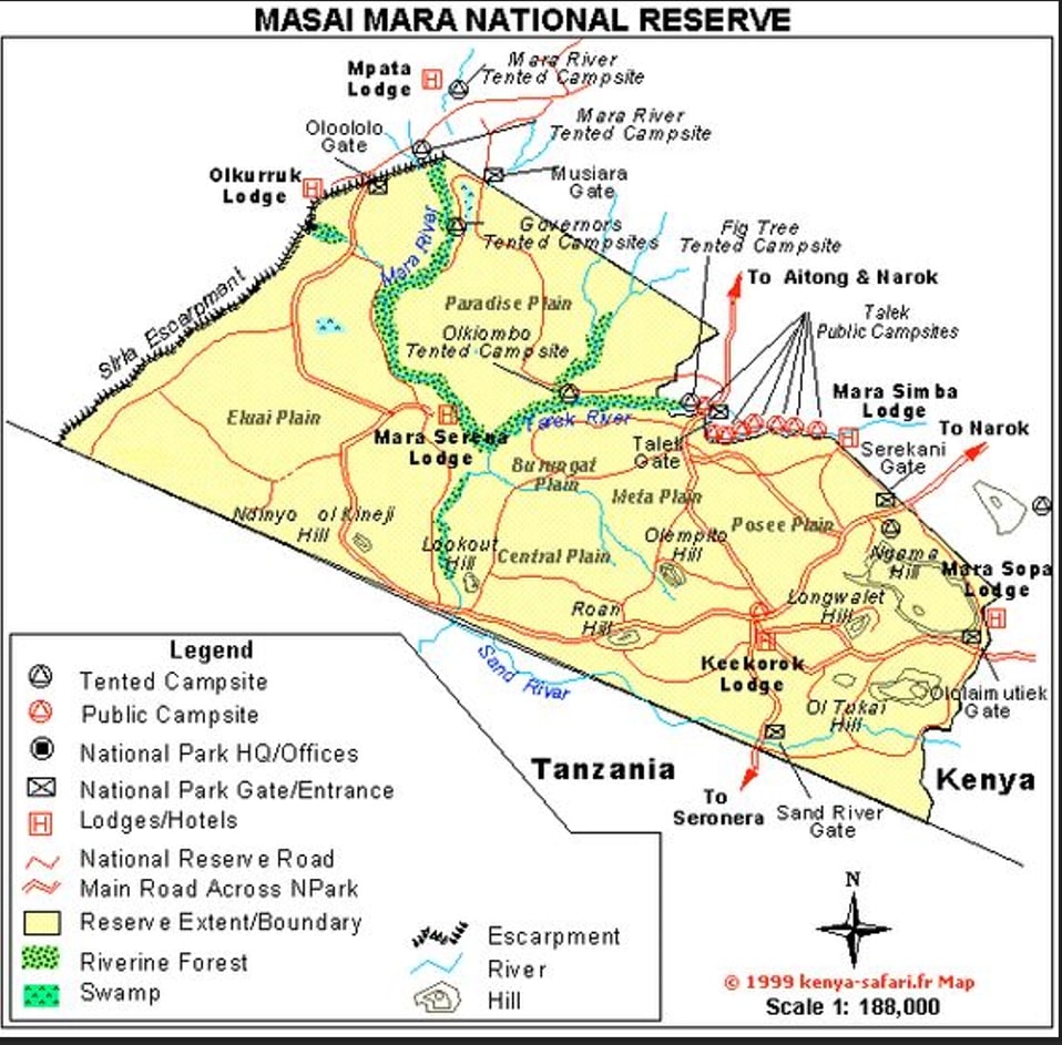
- Several entry gates including Oloololo Gate, Musiara Gate, Talek Gate, Sand River Gate, and Oloimutiek Gate
- Various landmarks such as Rekero Rock, Look Out Hill, and Leopard Gorge
- Swamp areas like Olpunyata Swamp
- Clear directions to neighboring areas like Narok, Nairobi, and Tanzania
The Main Regions of the Maasai Mara Kenya Map
When examining the Masai Mara National Reserve map, you’ll notice several distinct regions:
You can also check our Serengeti Map.
The Main Plains and Landmarks
The official Masai Mara National Reserve contains various notable plains and landmarks:
- Paradise Plain: Located near the Mara Triangle and known for excellent wildlife viewing
- Musiara Marsh: In the northern section, providing a vital water source for wildlife
- Rhino Ridge: An elevated area offering panoramic views of the surrounding savannah
- Leopard Gorge: Located in the northern section, known for leopard sightings
- Burungat Plain: A central plain with abundant wildlife
- Posset Plains: Located in the eastern section of the reserve
- Maji ya Fisi and Meta Plains: In the southeastern region
The Border Areas and Access Points
The map clearly shows the border with Tanzania to the south, marked by a dashed line. Key features in this area include:
- Sand River Gate: The southern entrance connecting to Tanzania’s Serengeti
- Sand River: Running along the southern boundary
- Mara River Crossings: Essential routes for the Great Migration
Accessing the Masai Mara via the Map
Understanding the Masai Mara map is essential for planning your journey. As shown on the map, the reserve can be accessed through several gates:
- Oloololo Gate: Western entrance near the Siria Plateau
- Musiara Gate: Northern entrance, providing access to Musiara Marsh and Leopard Gorge
- Talek Gate: Eastern entrance near Talek River
- Sand River Gate: Southern entrance connecting to Tanzania
- Oloimutiek Gate: Southeastern entrance
The map shows several directions to and from the reserve:
- Routes to Narok and Nairobi from the eastern side
- Connections to Lolgorien and Migori/Kisii from the northwest
- Access to Lotta Hills to the southeast
- Routes to Aitong to the northeast
Camps and Accommodations
The map highlights two notable camps within the reserve:
- Mara Intrepids: Centrally located near Rekero Rock
- Mara Explorer: Also centrally positioned for optimal game viewing
Wildlife Migration Routes on the Masai Mara National Reserve Map
The map provides valuable information about wildlife movements across the reserve:
- Migration Crossings: Several marked crossing points along the Mara River, including the famous Paradise Crossing in the Mara Triangle area
- Wildlife Herds: The map’s legend indicates locations of Serengeti herds, Lotta herds, and Zebra herds
- Salt Lick: Located in the western part of the reserve, an important mineral source for wildlife
- Mara River: Famous for dramatic wildebeest crossings during the Great Migration (July to October)
- Paradise Plain: An open grassland area known for excellent wildlife viewing
- Rhino Ridge: Elevated area offering panoramic views and wildlife spotting opportunities
- Musiara Marsh: Permanent water source attracting diverse wildlife year-round
- Leopard Gorge: Known for leopard sightings in the northern section
Understanding these wildlife hotspots and migration routes shown on the Masai Mara map helps visitors maximize their game viewing opportunities.
Planning Your Safari with the Maasai Mara Kenya Map
At Twinkle Star Tours and Safaris, we use our intimate knowledge of the Masai Mara map to create personalized Masai mara safari itineraries. Based on the map details, consider these factors when planning:
- Season: The Great Migration typically crosses the Mara River at designated crossing points from July to October, but the Mara offers excellent wildlife viewing year-round
- Location preferences: The map shows distinct areas like Paradise Plain, Rhino Ridge, and Musiara Marsh, each offering unique experiences
- Accommodation location: Consider staying at centrally located camps like Mara Intrepids or Mara Explorer for optimal game viewing
- Access points: Decide which gate is most convenient based on your starting point Nairobi, Narok, or other locations marked on the map.
- Special interests: Whether you’re passionate about big cats (visit Leopard Gorge), witnessing river crossings, or exploring various plains, different areas excel for different experiences
Key Landmarks on the Map of Masai Mara Game Reserve Kenya
As shown on the map, the Masai Mara features several notable landmarks:
- Rekero Rock: A prominent geological feature near the Mara Intrepids camp
- Look Out Hill: Offering panoramic views of the southern plains
- Bila Shaka: Located in the northeastern section
- Double Cross: A notable landmark in the northeast
- Fig Tree: A prominent marker in the northeast section
- Keekorok: A notable area in the southeastern region
- Olpunyata Swamp: A wetland area in the western section of the reserve
Each of these landmarks serves as an important navigation point and often offers unique wildlife viewing opportunities.
Understanding the Masai Mara Border with Tanzania
As clearly shown on the masai mara national reserve map, the southern boundary of the reserve borders Tanzania’s Serengeti National Park, marked by a dashed line. This connection is crucial for understanding the Great Migration:
- Wildlife freely crosses between the Serengeti and Masai Mara following ancient migration routes
- The Sand River Gate serves as an official border crossing point
- Herds from the Serengeti (marked in the map’s legend) move northward into the Masai Mara during the migration season
- The Mara River flows across this border, creating the famous crossing points that attract visitors from around the world
Experience the Masai Mara with Twinkle Star Tours and Safaris
Our experienced guides have unparalleled knowledge of the Masai Mara map, allowing us to:
- Navigate efficiently to the best wildlife viewing areas shown on the map, such as Paradise Plain, Rhino Ridge, and Musiara Marsh
- Position vehicles optimally at river crossing points for witnessing the Great Migration
- Explore the diverse plains marked on the map, from Topi Plains to Burungat Plain
- Visit iconic landmarks like Leopard Gorge, Rekero Rock, and Look Out Hill
- Ensure you experience the full diversity of landscapes depicted on the Masai Mara map
Conclusion
The map of Masai Mara Game Reserve Kenya reveals a complex and magnificent ecosystem waiting to be explored. From the Mara River crossings to Leopard Gorge, from Paradise Plain to Rhino Ridge, each area offers unique wildlife experiences. With Twinkle Star Tours and Safaris, you’ll experience this remarkable landscape with experts who understand its geography, wildlife patterns, and hidden treasures.
Contact us today to plan your personalized Masai Mara safari adventure. Our team will help you navigate the Masai Mara National Reserve map to create memories that will last a lifetime.